Skip to content
Amber Jean McCullum (she/her)
Applied Earth Scientist
Version 2
I have multiple roles within Applied Sciences and Capacity Building at NASA, where my work centers around delivering remote sensing trainings for global communities, engagement and capacity building with Indigenous communities on their use of Earth Observations for natural resources, and assessing the impact of water resources projects on decision-making in the western U.S.
Current research
Questions
I am most interested in how people find, use, interpret, and communicate Earth science and remote sensing data for the issues their community is facing. This covers a wide range of research questions from things like: “how severe is the drought this year compared to previous years?” or “how many acres of the forest were burned from a recent fire?” or “how can we engage Indigenous youth in STEM to benefit their communities?” I have a passion for the translation of data into knowledge, and for connecting science to community.
Approach
In two of my roles with BAERI I create trainings that are relevant to specific topic areas or communities. I work for NASA’s Applied Remote Sensing Training (ARSET) program, where we conduct online trainings for a global audience on land management and wildfires issues. I am also the lead for NASA’s Indigneous Peoples Capacity Building Initiative, where we work closely within communities on trainings, engagement, and dialogue.

Another approach I have taken is through applied research projects that focus on the co-development of remote sensing tools with a partner group. In one such project, conducted in partnership with the Navajo Nation Department of Water Resources and the Desert Research Institute, we collaboratively designed an online webtool called the Drought Severity Evaluation Tool (DSET) on the Navajo Nation to assist with drought reporting that includes ground-based and satellite data. Establishing and maintaining relationships, especially focusing on free, prior, and informed consent, is key to true co-development of NASA capabilities for communities. Our partners provided feedback along the way, so we could create a user-friendly application that is being used to assist with drought emergency declarations. We are now working on a project focused on the use of the OpenET platform for assessing agricultural water use on the Nation. Co-development and partner-driven solutions are also integral to my work with the Western Water Applications Office, where I am the Impact and Transition Lead. Here I focus on how our water projects benefit decision making and how we can sustain the capabilities and relationships for the long term.

Technical Description
The Navajo Nation Drought Severity Evaluation Tool (DSET)
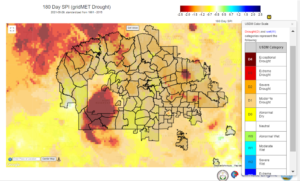
In data scarce regions of the world, co-produced management tools that combine remote sensing, modeled, and in situ data provide the information needed to support ground-based monitoring systems for improved water and natural resource management. On the Navajo Nation (N.N.), in the Four Corners of the southwestern United States, there is a need for data-driven management of water resources as the region is prone to water scarcity and emergency drought declarations, which have become more common under a changing climate. The current tools used by the N.N. Department of Water Resources largely lack the spatial detail, consistent measurements, and political and administrative information specific to their needs for determining appropriate response actions. The Drought Severity Evaluation Tool (DSET), a cloud-based web application that harnesses the capabilities of Google Earth Engine, is a user-friendly tool that pairs remotely sensed, modeled, and in situ data on the N.N. The DSET computing capabilities include on-the-fly generation of regional to field scale maps, time series figures, and reporting metrics that can assist in drought emergency declarations and allocation of relief dollars across the N.N. to the regions that need it most.
OpenET
OpenET is a satellite-based ET cloud computing and data services platform that builds upon decades of research by NASA, USGS and USDA, and involves more than 45 scientists and software engineers from four NASA Centers (ARC, MSFC, JPL, GSFC), USGS, USDA, seven universities including Desert Research Institute (DRI), and non-governmental organization (NGO) and private sector partners. OpenET provides daily, monthly, and annual ET data at a spatial resolution of 30 m x 30 m (0.22 acres) using Landsat, gridded weather data, and an ensemble of well-established satellite-driven ET models implemented on the Google Earth Engine cloud computing platform. Google Earth Engine allows for efficient interoperability across different datasets, massive parallel processing, storage, scalability in time and space, and automated operational updates with new observations that would otherwise be costly and burdensome for State and federal agencies to develop, operate, and maintain. The Navajo Nation is incorporating data from OpenET into their own drought and water management tools, and expanding capacity and outreach efforts to increase the use of OpenET among water managers, farmers, and agricultural communities across the Navajo Nation.
Applied Remote Sensing Training (ARSET)
ARSET offers online and in-person trainings for beginners and advanced practitioners alike. Trainings cover a range of datasets, web portals, and analysis tools and their application to air quality, agriculture, disaster, land, and water resources management. Since 2009, the program has reached over 32,000 participants from 170 countries and more than 7,500 organizations worldwide.
Western Water Applications Office (WWAO)
Our mission is to improve how water is managed in the arid western U.S. by getting NASA science, data, and technology into the hands of water managers and decision makers. WWAO partners with water managers, identifies pressing water issues, and delivers solutions to those issues based on NASA capabilities.
Education
I received a B.S. in Geology and Environmental Geosciences from the College of Charleston, a M.S. in Geology from San Francisco State University, and a PhD in Environmental Studies from the University of California Santa Cruz. My academic career focused on water resource availability with climate variability and change.
Get in touch: mccullum (at) baeri.org

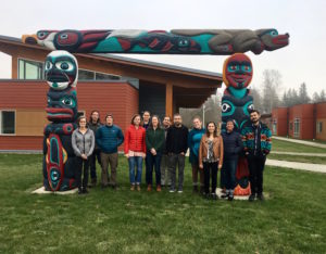
Participants in the Indigneous Peoples Capacity Building training in 2017. This training was held in partnership with the Samish Indian Nation and Northwest Indian College, in Bellingham Washington.
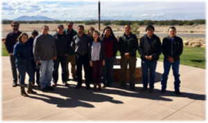
Participants in the Navajo Drought training and listening session held in Flagstaff, AZ in 2019.
The Navajo Drought Severity Evaluation Tool (DSET) displaying the 6-month Standardized Precipitation Index (SPI), for June 2021. The red regions indicate extreme and exceptional drought conditions, as outlined by the US Drought Monitor designations. This map was used to assist in a drought emergency declaration on the Navajo Nation.
Publications
Google Scholar
External Links
Current Projects
About Amber
Where are you from, and what were you doing before BAERI?
I grew up in northwest Indiana, in a rural community, and I currently reside in Oakland, CA. Before coming to BAERI I worked as a Staff Geologist for a large environmental consulting firm, Environmental Resources Management (ERM), in Charleston South Carolina, where I conducted cultural and environmental assessments for cellular service companies. I also began with NASA as an intern for the DEVELOP program before becoming an employee with BAERI.
What’s one job-related thing that you love talking about with other people?
I love discussing how NASA data is being used for everyday science that anyone can relate to, such as locating where wildfires are burning, or identifying habitats for birds, or monitoring floods. I also love telling people that, yes, NASA does Earth Science!
How about a non-job related thing?
I love camping and getting lost in nature. My partner and I recently bought a camper van and are fixing it up to get out and explore our beautiful state with our daughter.
We are a community of researchers, engineers,
explorers, writers, and more. Our shared belief
in the power of science inspires our work to
better understand our planet, and the universe.
Back To Top