
BAERI’s Pardhasaradhi Teluguntla (Pardha) (first author) and his co-authors have received the first place 2026…
Shadows & Greenness: Uncovering Satellite Biases in Viewing Earth’s Vegetation
For decades, scientists have used satellite data to assess the health and greenness of Earth’s vegetation. These data have influenced our understanding and decision-making on pressing issues from sustainable crop production to climate change. Plants that grow on land absorb one-third of anthropogenic carbon emissions annually, which significantly helps to mitigate the emerging impacts of climate change worldwide. Earth’s vegetation is the main source of food for the global population of wildlife and eight billion people.
Scientists recently noticed a puzzling pattern they could not explain in satellite-derived vegetation greenness, a measurement that is used as a proxy for the amount of leaves in an area and for vegetation productivity. The puzzle was that vegetation-greenness measures over the US Corn Belt are higher than the same measures over the Amazon rainforest, despite the rainforest having a greater amount of leaf area. Specifically, the Amazonian forests have about two times more leaves per unit area than the US Corn Belt (5.7±0.6 m2/m2 vs. 2.6±0.3 m2/m2, respectively). So, while you may think that it’s common sense that the Amazon’s greenness measure would be significantly higher than the greenness measure of the Corn Belt—it’s not! A new study published in Nature Ecology & Evolution finally provides an answer to the cause of this paradoxical pattern and unveils a startling insight, which suggests that we may have been viewing the Earth through a distorted lens.
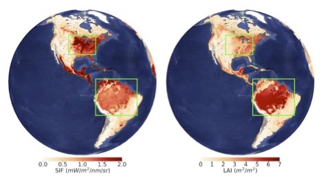
Spatial pattern of solar-induced chlorophyll fluorescence (SIF, Left) and leaf area index (LAI, Right). SIF is an innovative measurement that serves as a proxy for plant photosynthetic activity. LAI is the green leaf area of a canopy or plant community per unit ground area. SIF and LAI data presented here are from ESA Sentinel-5 Precursor TROPOMI and NASA Terra/Aqua MODIS, respectively. Image: Fujiang Ji.
A team of researchers from 12 institutions across five different countries, including University of Wisconsin–Madison, NASA’s Ames Research Center, and Pacific Northwest National Laboratory (PNNL), found that vegetation-greenness measures are often shadowed—literally. Shadows, especially those cast by complex canopy structures, can introduce pronounced negative biases into satellite-derived greenness measures, thus misleading our understanding of global vegetation and how it’s changing.
“We hypothesized that the shadows cast by complex canopies might contribute to this paradoxical phenomenon. The complex canopy of the Amazon rainforests, in contrast to the relatively simple and homogeneous canopies of the US Corn Belt, provides the ideal natural experiment for testing our hypothesis, because varying canopy-structure complexity creates contrasting shadowing conditions,” said Yelu Zeng, a lead author of this study and professor at China Agricultural University (previously a research scientist at University of Wisconsin–Madison when this work was first undertaken).
To prove that canopy-cast shadows can lower satellite vegetation-greenness measures, the researchers explicitly tracked how light interacts with the vegetation canopy. They did this investigation with state-of-the-art radiative transfer modeling. They incorporated multi-angular, hyperspectral, and lidar data from several NASA missions and programs. The team placed particular emphasis on the importance of the geometry between the satellite, the Sun, and the Earth’s vegetation.
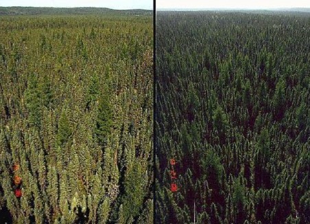
This is a black spruce forest in the NASA-supported BOREAS (Boreal Ecosystem-Atmosphere Study) field campaign region in Canada. (Left) Trees are viewed with the Sun behind the observer. All shadows are concealed, and only the bright side of the trees is visible. (Right) Trees are viewed with the Sun opposite the observer. Large shadows are visible. Image: Don Deering.
“Imagine you stand looking at trees with the Sun behind you. You will see brighter leaves with fewer shadows. Now, consider the opposite scenario, where the Sun is in front of you. You will observe more shadows and darker leaves,” said Taejin Park, a research scientist at NASA Ames Research Center / Bay Area Environmental Research Institute (BAERI) and co-first author of this study. “A more complex canopy structure results in more shadows, which in turn makes the impact of those shadows more significant.”
The consequences of the shadow effect extend far beyond the technical interpretation of satellite data. In their paper, the team investigates what this means for global vegetation studies. In one example, they showcase how land conversion from forest to crops reveals an unexpected increase in vegetation greenness in satellite data, even though the land loses green leaves when forests are replaced by crops.
“A significant portion of deforestation in the Amazon rainforest is due to cropland expansion. Our results, which demonstrate an increase in vegetation greenness after the conversion of forest into cropland, are thus important and striking.” said Dalei Hao, a research scientist at PNNL and a co-first author of this study.
The authors stress that the shadow effect needs to be taken into account for a variety of satellite-based greenness measures, including solar-induced chlorophyll fluorescence (SIF). SIF is an innovative and popular way to measure the photosynthetic activity of plants and is a measurement that many Earth observing satellites are collecting for use in global vegetation studies.
“It is important to clarify that shadows are a real component of vegetation canopies, and that the shaded portion usually represents a large percentage of the canopy’s total carbon, water, and energy budget. However, our understanding of these shadows is limited, which highlights the need for in-depth future studies,” said Min Chen, a professor at University of Wisconsin–Madison and a co-author of this study.
Understanding the true state of Earth’s vegetation is crucial for everyone. Misinterpretations could lead to heightened uncertainty in climate models, misguided agricultural policies, and ineffective conservation efforts. To avoid misinterpretations, the researchers propose adjustments that could offer a more accurate picture by minimizing the shadow effect, specifically by shifting the satellite’s viewing condition to what is known as the “hotspot direction,” where the Sun is positioned behind the satellite. The team suggests that scientists need to exercise caution when using satellite vegetation greenness for biome-to-biome comparisons or when assessing rapid land-conversion processes. Such usage may introduce unexpected biases or errors when evaluating regional and global vegetation changes and growth trends.
Related Posts